

| NEW SOUTH WALES | |||
| Snow forecast | 5 Days | 10 Days | 15 Days |
| Perisher | 0cm | 0cm | 0cm |
| Thredbo | 0cm | 0cm | 0cm |
| Charlotte Pass | 0cm | 0cm | 0cm |
| Selwyn | 0cm | 0cm | 0cm |
| VICTORIA | |||
| Snow forecast | 5 Days | 10 Days | 15 Days |
| Falls Creek | 0cm | 0cm | 0cm |
| Mt Hotham | 0cm | 0cm | 0cm |
| Mt Buller | 0cm | 0cm | 0cm |
| Mt Baw Baw | 0cm | 0cm | 0cm |
Please note: the 10-15 day readings are more likely to change due to the longer range timeframe.
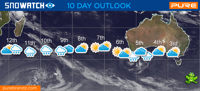
Welcome to the first week of forecasts for 2024. We are looking forward to a much improved season as last year was up there with the worst on record.
At the moment weather patterns for the southern hemisphere are pretty normal for this time of year with strong high pressure systems dominating. This means that most cold fronts slide south under the mainland. We do have some light snow possible about the peaks over the next couple of weeks but nothing that will hang around.
Possible snow around the 18th after some showers and rain, although this system is probably more likely to slide just under the mountains.
What we do need will be cold nights from late May so the snowmakers can get firing and build a base.
Long range keep an eye on around the end of the month around the 30th for a cold blast. This looks like our best chance of some decent early snow.
Pete 'The Frog' Taylor
....
If publishing any of the above forecast outlook please quote Snowatch.com.au as the source.


| MAY | ||||||
| SUN | MON | TUE | WED | THU | FRI | SAT |
| 1 | 2 | 3 | 4 | |||
| 5 | 6 | 7 | 8 | 9 | 10 | 11 |
| 12 | 13 | 14 | 15 | 16 | 17 | 18 |
| 19 | 20 | 21 | 22 | 23 | 24 | 25 |
| 26 | 27 | 28 | 29 | 30 | 31 | |
| JUNE | ||||||
| SUN | MON | TUE | WED | THU | FRI | SAT |
| 1 | ||||||
| 2 | 3 | 4 | 5 | 6 | 7 | 8 |
| 9 | 10 | 11 | 12 | 13 | 14 | 15 |
| 16 | 17 | 18 | 19 | 20 | 21 | 22 |
| 23 | 24 | 25 | 26 | 27 | 28 | 29 |
| 30 | ||||||
| No Snow | Light Snow | Heavy Snow |